Well we all knew it was possible: location by cell information. It's just that it hasn't really turned up in that many mainstream mobile applications. So hats off to Google with Maps for Mobile 2.0. They've managed to turn an already great application into quite simply one of the best, must-have free mobile applications available.
 If you haven't heard, Google Maps 2.0 was announced last week, with My locations (beta) technology. It uses cell tower information to figure out the approximate location of the mobile device without GPS. This information is then overlaid on a real map (satellite image or street map). This is the best non-GPS location based application I've seen. Of course, using cell information is not as accurate as GPS, but the advantages are significant: it is faster than its GPS counterpart, as it can often take some time to acquire the necessary number of satellite locks to get a GPS fix; and it is available on a much wider range of phones, rather than the small proportion of expensive phones with GPS hardware. Of course, if you have a GPS-enabled phone, then Google Maps can make use of this technology too!
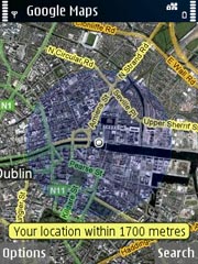
In the attached image, the application has zeroed in on my location. A wide error margin, 1700 metres, is reported in this case, but in fact the center of this zone is within 200 metres of my true location. Very impressive stuff.
Location from cell-tower id is not a new idea, but it seems that not many people in a position to do something with this data have taken the initiative. So once again: great job, Google!
It would be nice to see more LBS applications brought to the masses in this way – for those who really can't wait, how about a My Location mashup with SATLAV?
To download Google Maps for Mobile, visit http://www.google.com/gmm on your mobile browser


